TYPHOON
BABS
in
the
Philippines
(14-25
Oct
98)
by
Jennifer
Chong
After Typhoon Zeb, it is now powerful Category 4 Tyhpoon Babs hitting
north Philippines at a maximum winds speed of 120 knots gusting to 145
knots (approx. 140 mph to 160 mph). It is moving west-north-westward
at 8 knots towards China on 22 Oct 98 (Thurs).
Meanwhile in Sabah, the sea winds is blowing at 40 Km/h to 50 Km/h
south-westward and the forecasted waves height is 2.0 m to 3.0 m (dangerous
to small boats). KK area is showered with heavy rain and with strong
winds blowing on and off mostly in the evening. However, in the Sulu
Sea which is located to the north of Sabah, the sea winds condition is
20 Km/h to 40 Km/h and the waves height is 1.0 m to 2.0 m high.
 Check
out the diagram beside for the direction Typhoon babs is heading and the
winds speed on its way. The colour of the arrow showing the path
is as per the Saffir-Simpson Scale and the speed used in in knots as per
the scale at the bottom left of the diagram. This diagram is captured
on 22 Oct 98 itself. See the latest plotted diagram on Typhoon Babs
at:- http://www.solar.ifa.hawaii.edu/Tropical/GifArchive/BABS-98.gif
Check
out the diagram beside for the direction Typhoon babs is heading and the
winds speed on its way. The colour of the arrow showing the path
is as per the Saffir-Simpson Scale and the speed used in in knots as per
the scale at the bottom left of the diagram. This diagram is captured
on 22 Oct 98 itself. See the latest plotted diagram on Typhoon Babs
at:- http://www.solar.ifa.hawaii.edu/Tropical/GifArchive/BABS-98.gif

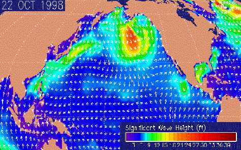
Click on the map on the left to see sea winds direction and waves
height on 22 Oct 98.
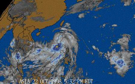
The image at the right shows satelite view of cloud spread on 22
Oct 98. Clouds covered most of Philippines and Sabah shows Typhoon
Babs at work.
Hurricane is the
name for a tropical cyclone with sustained winds of 74 miles per hour (65
knots) or greater in the North Atlantic Ocean, Caribbean Sea, Gulf of Mexico,
and in the eastern North Pacific Ocean. This same tropical cyclone is known
as a typhoon in the western Pacific and a cyclone in the Indian Ocean.
For comments / suggestions / feedback, email to
Samuel at :
samcch@hotmail.com