![]()
INTRODUCTION
There has been considerable interests in
La Niña generated lately through the internet emails and also in
the news in August and September 1998. The Meteorological Department
in KK has been receiving hundreds of calls enquiring about the worst and
most ridiculous scenarios of La Niña. Judging by the public
reaction in the news and through the grapevine, I guess the reactions are
based on lack of information and knowledge. It is hoped that this
page will provide what information and knowledge that is lacking and in
the process also give assurance, allay fears and give a sense of security.
There are many sites on the internet which
monitor and forecast weather. The following sources of information,
put together, can be used to monitor the weather in Sabah during this season.
I am not a meteorological expert and not an enthusiast in monitoring the
weather. However, ever since interests and fears on La Niña
has been generated here in Sabah recently, I decided to search the internet
to find out more and to monitor the situation closely if possible so that
our fears can be put to rest. Sabah is actually quite well protected
from severe weather conditions (strong winds) by the Philippines and the
Indonesian Islands. After a short
period of monitoring Sabah weather, I have come to a better understanding
of why our land is known as 'land below the wind'.
![]()
CURRENT
FORECAST
The first site you should check out is
our very own Malaysian Meteorological Services (MMS). Check out their
weather forecast and storm warning pages for Sabah at
MMS
- current forecast
Alternatively, you can try other independent global forecast sites at :
Weather Underground : Favorite Weather places
 For
those living near the seaside and have a fear of tidal wave, check out
MMS' page on wind and sea conditions at
For
those living near the seaside and have a fear of tidal wave, check out
MMS' page on wind and sea conditions at
MMS's
wind & sea conditions
For your information (as comparison), the
top wind speed during the 1996 Greg Tropical Storm was about 120 km/h (with
wave height probably around 5 M high, not sure - can't remember).
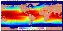
Another
link to check on wind and sea conditions is at
Global
wind -sea wave height map
This site contains a graphic picture like
the one shown beside here indicating the wind and sea wave height.
The implication from monitoring sea wave height is : the higher the
waves, the stronger the wind - low waves means slow wind and no tidal wave.
Sabah in the South China Seas, being the 'Land below the wind', is fortunate
to be in the dark blue most of the time (less than 6ft high waves), in
fact since I started monitoring this page in August 1998.
The complete global detail sea wave and marine information can be
obtained from
marineweather.com
back to top
SATELITE
IMAGES - CLOUD COVER
For those interested in more high tech sources,
check out the satelite images for our South East Asia region which will
indicate the amount of cloud cover (and possible rainfall)
Satelite Image (from WeatherNet) - cloud cover
 I do not know how to interpret these images
as a layman but it is only common sense that there cant be any rain if
there is no cloud (like during the El Nino season last year). On
the other hand, I have also observed that sometimes, even though there
were heavy widespread cloud cover from the Satelite's viewpoint, there
was no rain down here on earth ! I normally combine Satelite images
with MMS' forecast and Weather Underground's forecast to interpret what
I see from the images.
I do not know how to interpret these images
as a layman but it is only common sense that there cant be any rain if
there is no cloud (like during the El Nino season last year). On
the other hand, I have also observed that sometimes, even though there
were heavy widespread cloud cover from the Satelite's viewpoint, there
was no rain down here on earth ! I normally combine Satelite images
with MMS' forecast and Weather Underground's forecast to interpret what
I see from the images.
Other similar satelite images can be obtained from :
MMS - Satelite image from our very own MMS' homepage
Weathernet - click this for best view of entire East Asia Region
Accu weather - Satelite image from Papua New Guinea to Japan to Thailand
WeatherNet - Radar & Satelite images for entire world
Rave
Satelite Links - Images from various satelites for various parts of
the world
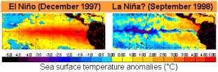
 Click on this link to view the latest Sea Surface
Temperature Global Map. Sea Surface Temperature is linked to wind
speed and wave height (all interrelated in an equation, I think).
Click on this link to view the latest Sea Surface
Temperature Global Map. Sea Surface Temperature is linked to wind
speed and wave height (all interrelated in an equation, I think).
http://www.marineweather.com/SSTMGLB.html
back to top
What
is El Niño & La Niña?
El Nino and La Niña are not names of winds or storms like Tropical Storm Greg or Bertha or others. They are names for periodical weather phenomenons, much like annual seasons, but they are more pertaining to special weather conditions that occur not annually but periodically over a number of years. Effects of the La Niña phenomenon include heavier than usual rainfall, strong winds, etc.
El Niño means The Little
Boy or Christ child in Spanish. This name was used for the
tendency of the phenomenon to arrive around Christmas. La Niña means
The Little Girl. La Niña is sometimes called El Viejo, anti-El
Niño, or simply "a cold event" or "a cold episode".
![]() La
Niña is characterized by unusually cold ocean temperatures in the
Equatorial Pacific, as compared to El Niño, which is characterized
by unusually warm ocean temperatures in the Equatorial Pacific. El
Niño occurs more frequently than La Niña.
La
Niña is characterized by unusually cold ocean temperatures in the
Equatorial Pacific, as compared to El Niño, which is characterized
by unusually warm ocean temperatures in the Equatorial Pacific. El
Niño occurs more frequently than La Niña.
Click here
for more background information.
The
Origin of the names, La Niña and El Niño
The National Center for Environmental
Prediction (NCEP)
has a list of previous El Niño and La Niña years - Click
here for more information.
back to top
More
Links to Information on La Niña and El Niño
http://www.pmel.noaa.gov/toga-tao/la-nina-story.html#names
![]() NOAA
La Niño
page (http://www.elnino.noaa.gov/lanina.html)
NOAA
La Niño
page (http://www.elnino.noaa.gov/lanina.html)
![]() 1997-1998
El Niño Information (http://www.pmel.noaa.gov/toga-tao/el-nino/1997.html)
1997-1998
El Niño Information (http://www.pmel.noaa.gov/toga-tao/el-nino/1997.html)
![]() Frequently
Asked Questions (http://www.pmel.noaa.gov/toga-tao/el-nino/faq.html)
Frequently
Asked Questions (http://www.pmel.noaa.gov/toga-tao/el-nino/faq.html)
![]() Predictions
and Forecasts (http://www.pmel.noaa.gov/toga-tao/el-nino/forecasts.html)
Predictions
and Forecasts (http://www.pmel.noaa.gov/toga-tao/el-nino/forecasts.html)
![]() Present
conditions in the tropical Pacific (http://www.pmel.noaa.gov/toga-tao/realtime.html)
Present
conditions in the tropical Pacific (http://www.pmel.noaa.gov/toga-tao/realtime.html)
![]() El
Niño Theme Page (http://www.pmel.noaa.gov/toga-tao/el-nino/home.html)
El
Niño Theme Page (http://www.pmel.noaa.gov/toga-tao/el-nino/home.html)
![]() Discussion
of global precipitation differences in El Niño and La Niña
years
Discussion
of global precipitation differences in El Niño and La Niña
years
(http://dao.gsfc.nasa.gov/experiments/assim54A/sample_results/elnino.html)
![]() El
Niño terminology (http://www.pmel.noaa.gov/toga-tao/ensodefs.html)
El
Niño terminology (http://www.pmel.noaa.gov/toga-tao/ensodefs.html)
![]() WeatherNet
Radar & Satelite Products (http://cirrus.sprl.umich.edu/wxnet/radsat.html)
WeatherNet
Radar & Satelite Products (http://cirrus.sprl.umich.edu/wxnet/radsat.html)